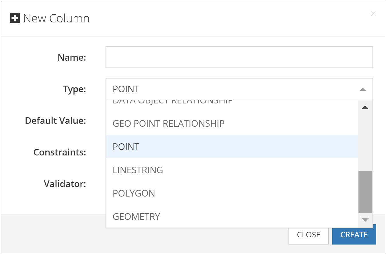
Spatial Data Types
Backendless database supports the following spatial data types:
POINT- represents a single point/location in coordinate space. For the points representing locations on a map, the coordinates are longitude and latitude.LINESTRING- represents a geometry consisting of a collection of points with linear interpolation between them. For example, a linestring can represent a delivery route.POLYGON- a closed geometrical shape consisting of a single exterior boundary and zero or more interior boundaries, also referred to as holes.
Additionally, Backendless supports a "parent" data type called GEOMETRY. This is the base type which can accommodate any of the data types listed above.
Spatial data in Backendless can be represented either in the WKT (Well-Known Text) or the GeoJSON formats. Backendless console supports both of these formats for entering new data or updating existing spatial values. Additionally, Backendless SDKs provide built-in classes which make it easier to work with the spatial data for all database operations, including creating, retrieving, updating and deleting spatial data.
POINT
The POINT type is used to represent a single point identified by two coordinates in a coordinates space. The coordinates are named X and Y, however, Backendless also handles these coordinates as longitude (X) and latitude (Y) to represent locations on a map. The WKT representation of this type is:
POINT (longitude latitude)
or
POINT (x y)
for example, the POINT below points to Dallas, TX
POINT (-96.7553535 32.8656106)
The GeoJSON format for the POINT values is:
{
  "type": "Point",
  "coordinates": [
    longitude or X,
    latitude or Y
  ]
}
A POINT value stored in the database is represented by the Backendless.Data.Point class in the client application. The class provides access to the point coordinates (x and y) which can also represent longitude and latitude in cases when the point identifies a location on a map. The class has the constructor and methods listed below. Notice that all set methods return the current Point object, which allows for convenient "chaining" for property assignments: pointInstance.setX( value ).setY( value ):
/**
* @public
* @class Backendless.Data.Point
*/
class Point {

 // creates a new instance of Point
constructor();

 //creates a Point object from a WKT definition
 static fromWKT(wellKnownText: string): Backendless.Data.Point;

 // creates a Point object from a GeoJSON definition
 static fromGeoJSON(geoJSON: string): Backendless.Data.Point;

 // retrieves the X coordinate of the point (same as longitude)
 public getX(): Number;

 // retrieves the Y coordinate of the point (same as latitude)
 public getY(): Number;

 // retrieves the longitude coordinate of the point (same as x)
 public getLongitude(): Number;

 // retrieves the latitude coordinate of the point (same as y)
 public getLatitude(): Number;

 // sets the x coordinate of the point (same as longitude)
 public setX(x: Number): Backendless.Data.Point;

 // sets the y coordinate of the point (same as latitude)
 public setY(y: Number): Backendless.Data.Point;

 // sets the longitude coordinate of the point (same as x)
 public setLongitude(x: Number): Backendless.Data.Point;

 // sets the latitude coordinate of the point (same as y)
 public setLatitude(y: Number): Backendless.Data.Point;

 // converts this Point object into its WKT representation
 public asWKT(): string;

 // converts this Point object into its GeoJSON representation
 public asGeoJSON(): string;

 // checks this Point object with another object for equality
 public equals(o: Object): boolean;
}
Consider the following example. The objects shown below contain a geometry column/property called location. The type of the column is POINT:
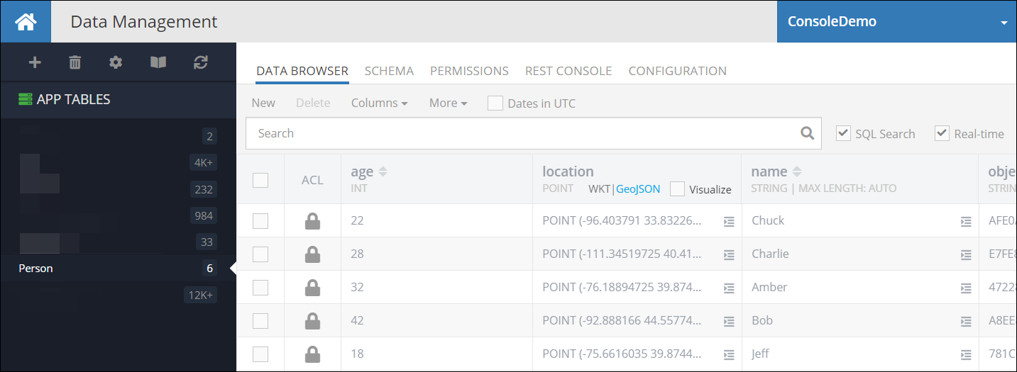
The following code retrieves the first object from the table. Notice how the geometry property is accessed. Backendless automatically converts POINT data type to an instance of the Point class:
Backendless.Data.mapTableToClass('Person', Person)

Backendless.Data.of(Person).findFirst()
.then(person => {
   const location = person.getLocation()
   const locationLatitude = location.getLatitude()
   const locationLongitude = location.getLongitude()
})
.catch(error => {

})
Codeless Reference
The Point data type is represented as a GeoJSON object in the Codeless. This object consists of two properties: longitude (x) and latitude (y):
where:
| Argument | Description |
|---|---|
longitude (x) |
Specifies the longitude coordinate of the geographic point. It represents the east-west position on the Earth's surface, measured in degrees. |
latitude (y) |
Represents the latitude coordinate of the geographic point. It denotes the north-south position on the Earth's surface, measured in degrees. |
Consider records in the following data table called geolocation:
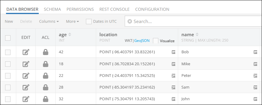
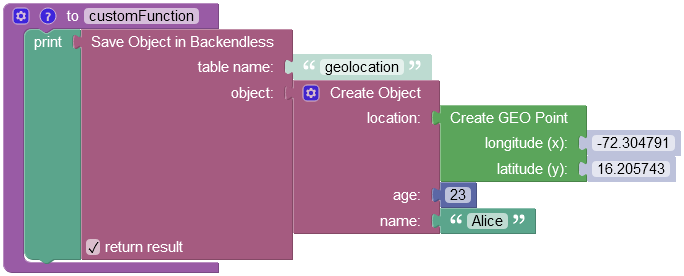
Suppose you need to add a record to the data table presented above. The example below saves a new GeoJSON object(POINT) to the geolocation data table: As you can see, the Codeless block contains an object with the location property, that represents the column in the data table where POINT data objects are stored.
where:
| Argument | Description |
|---|---|
table name |
Name of the data table where a new record must be saved. |
object |
An object to save in the database. Object properties must match the names of the table columns. The object must not have the objectId property. |
return result |
Optional parameter. When this box is checked, the operation returns the saved object with the objectId property. |
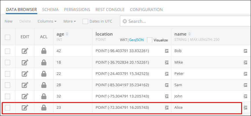
After the Codeless logic runs, the operation adds a new object to the data table:
In case you want to retrieve a specific object from the geolocation data table, refer to the Basic Object Retrieval topic to learn more about Codeless object retrieval operations.
LINESTRING
The LINESTRING type is used to represent geometries composed of multiple POINT values with linear interpolation between each two consecutive points. The WKT representation of this type is:
LINESTRING (lon1 lat1, lon2 lat2, lon3 lat3, lon4 lat4)
or
LINESTRING (x1 y1, x2 y2, x3 y3, x4 y4)
for example, the LINESTRING below identifies the main stops of the historic Route 66:
LINESTRING (-87.52683788 41.85716752, -90.13875858 38.68967135, -95.93953983 36.2131248, -97.49959842 35.53656483, -101.8282117 35.26791494, -105.87118045 35.72083154, -106.61825076 35.14794417, -111.63900272 35.20182535, -118.24178592 34.07195769)
The GeoJSON format for the LINESTRING values is:
{
  "type": "LineString",
  "coordinates": [
    [
      lon1 or x1,
      lat1 or y1
    ],
    [
      lon2 or x2,
      lat2 or x2
    ],
    [
      lon3 or x3,
      lat3 or y3
    ],
    [
      lon4 or x4,
      lat4 or y4
    ]
  ]
}
Database values of this type are represented by the Backendless.Data.LineString class in the client application. The class provides access to the Point objects making up the linestring. The class has the constructors and methods as listed below. Notice that all set method return the current LineString object, which allows for convenient "chaining": lineStringInstance.setPoints( value ).asWKT():
/**
* @public
* @class Backendless.Data.LineString
*/
class LineString {
 constructor(points: Point[]);

 // creates a LineString object from a WKT definition
 static fromWKT(wellKnownText: string): Backendless.Data.LineString;

 // creates a LineString object from a GeoJSON definition
 static fromGeoJSON(geoJSON: string): Backendless.Data.LineString;

 // returns a collection of Point objects making up this LineString
 public getPoints(): Backendless.Data.Point[];

 // sets a collection of Point objects to define the LineString
 public setPoints(points: Point[]): Backendless.Data.LineString;

 // converts this LineString object into its WKT representation
 public asWKT(): string;

 // converts this LineString object into its GeoJSON representation
 public asGeoJSON(): string;
}
Consider the following example. The Travel table has an object identifying a travel route. The route column is of the LINESTRING type, its value is visualized in the map in the screenshot below:

The following code retrieves the Travel object from the table, gets its route property (which is a LineString) and accesses the points making up the linestring:
const dataQuery = Backendless.DataQueryBuilder.create()
dataQuery.setWhereClause('name = \'Route 66\'')

Backendless.Data.of('Travel').find(dataQuery)
 .then(response => {
   const travelRoute = response[0]
   const routeName = travelRoute.name
   const routeDefinition = travelRoute.route
   const points = routeDefinition.getPoints()
 })
 .catch(error => {
 })
Codeless Reference
The LineString data type is represented as a GeoJSON object in the Codeless.
where:
| Argument | Description |
|---|---|
points |
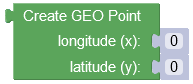
Represents a list containing Point objects. To populate the list, you must use the "Create GEO Point" Codeless block for each Point object you want to add. |
Consider record in the following data table called geolocation:
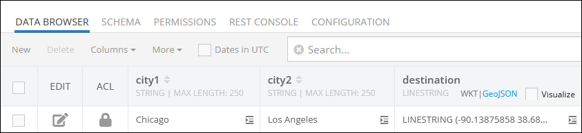
Suppose you need to add a new record to the data table presented above. In this context, the record to add represents a new destination between the city1 and the city2, the destination itself is presented as the LineString GeoJSON object stored in the destination property.
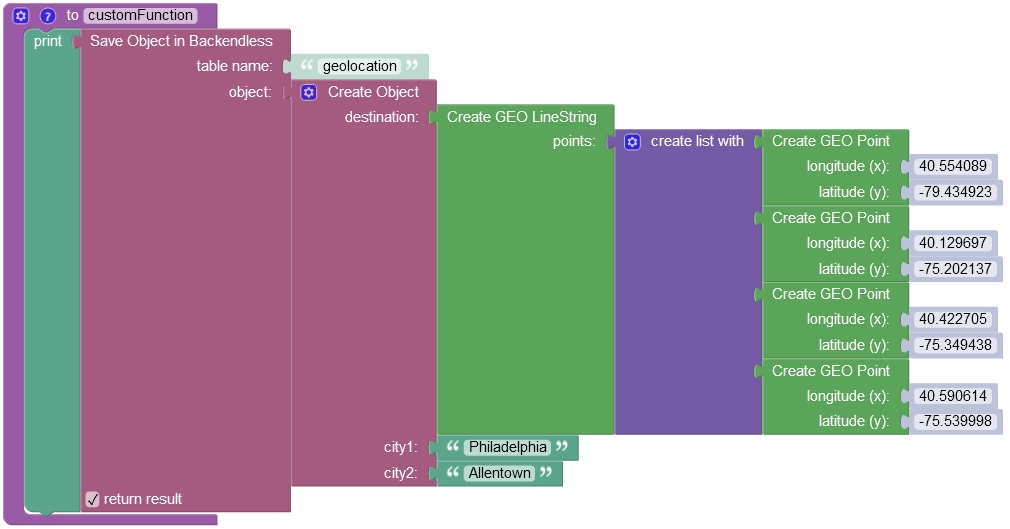
In the provided example, a new LineString object is being saved to the geolocation data table. The "Save Object" Codeless block is utilized, containing an object with the destination property representing the column in the data table. Within this property, the "Create GEO LineString" Codeless block is used, which includes a list consisting of multiple instances of the "Create GEO Point" Codeless blocks.
where:
| Argument | Description |
|---|---|
table name |
Name of the data table where a new record must be saved. |
object |
An object to save in the database. Object properties must match the names of the table columns. The object must not have the objectId property. |
return result |
Optional parameter. When this box is checked, the operation returns the saved object with the objectId property. |
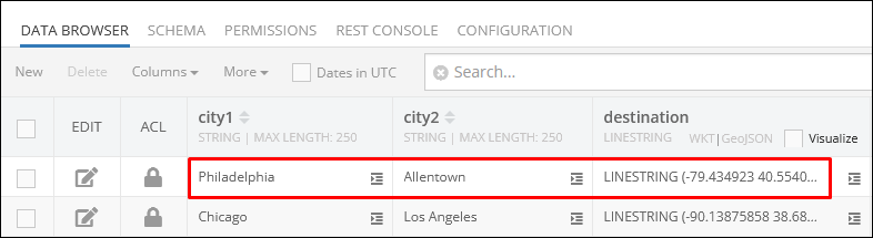
After the Codeless logic runs, the operation adds a new object to the data table:
In case you want to retrieve a specific object from the geolocation data table, refer to the Basic Object Retrieval topic to learn more about Codeless object retrieval operations.
POLYGON
Value of the POLYGON type is a figure that is described by a number of LINESTRING values connected to form a single continuous exterior boundary. Additionally, a Polygon may contain zero or more interior boundaries, where each interior boundary defines a hole in the Polygon. The WKT representation of this type is:
POLYGON ((lon1 lat1, lon2 lat2, lon3 lat3),
         (hole-lon1 hole-lat1, hole-lon2 hole-lat2, hole-lon3 hole-lat3),
         (...),(...))
or
POLYGON ((x1 y1, x2 y2, x3 y3),
         (hole-x1 hole-y1, hole-x2 hole-y2, hole-x3 hole-y3),
         (...),(...))
where the first group of coordinates defines the exterior boundary and all subsequent groups defines the holes. The first group is mandatory.
for example, the POLYGON below identifies the outline of The Pentagon - the US Department of Defense headquarters. It also includes a hole - which is the inner plaza.
POLYGON ((-77.05781934 38.87248788,
          -77.05474017 38.87287211,
          -77.0533025 38.8706001,
          -77.05556629 38.86883758,
          -77.05848453 38.87002374,
          -77.05781934 38.87248788),
         (-77.05669282 38.87156906,
          -77.05551265 38.87170271,
          -77.05494402 38.8708507,
          -77.05577014 38.87030775,
          -77.05688594 38.87074211,
          -77.05669282 38.87156906))
The GeoJSON format for the POLYGON values is:
{
  "type": "Polygon",
  "coordinates": [
    [
      [
        lon1,
        lat1
      ],
      [
        lon2,
        lat2
      ],
      [
        lon3,
        lat3
      ]
    ],
    [
      [
        hole-lon1,
        hole-lat1
      ],
      [
        hole-lon2,
        hole-lat2
      ],
      [
        hole-lon3,
        hole-lat3
      ]
    ]
  ]
}
Database values of this type are represented by the Backendless.Data.Polygon class in the client application. The class provides access to the LineString objects making up the polygon. The class has the constructors and methods as listed below. Notice that all set method return the current Polygon object, which allows for convenient "chaining" for property assignments: polygonInstance.setBoundary( value ).asWKT():
/**
* @public
* @class Backendless.Data.Polygon
*/
class Polygon {
 constructor(boundary: Backendless.Data.LineString | Backendless.Data.Point[], holes?: Backendless.Data.LineString[]);

 // creates a Polygon object from a WKT definition
 static fromWKT(wellKnownText: string): Backendless.Data.Polygon;

 // creates a Polygon object from a GeoJSON definition
 static fromGeoJSON(geoJSON: string): Backendless.Data.Polygon;

 // returns a LineString which defines the external boundary of the polygon
 public getBoundary(): Backendless.Data.LineString;

 public setBoundary(boundary: Backendless.Data.LineString | Point[]): Backendless.Data.Polygon;

 // returns a collection of LineString objects each identifying a hole
 public getHoles(): Backendless.Data.LineString[];

 public setHoles(holes: Backendless.Data.LineString[]): Backendless.Data.Polygon;

 // converts this Polygon object into its WKT representation
 public asWKT(): string;

 // converts this Polygon object into its GeoJSON representation
 public asGeoJSON(): string;
}
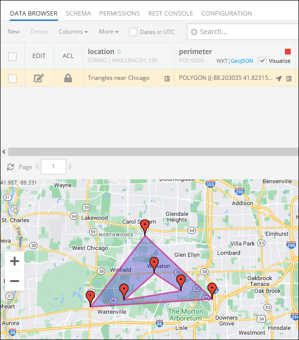
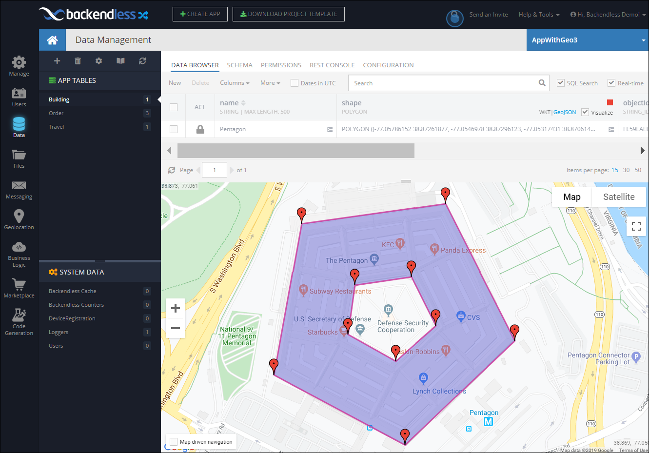
Consider the following example. The Building table has an object identifying a shape of a building. The shape column is of the POLYGON type, its value is visualized in the map in the screenshot below:
The following code retrieves the Building object from the table, gets its shape property (which is a Polygon) and accesses its external boundary and the hole.
const dataQuery = Backendless.DataQueryBuilder.create()
dataQuery.setWhereClause('name = \'Pentagon\'')

Backendless.Data.of('Building').find(dataQuery)
 .then(response => {
   const building = response[0]
   const buildingName = building.name
   const buildingShape = building.shape
   const externalBoundary = buildingShape.getBoundary()
   const holes = buildingShape.getHoles()
 })
 .catch(error => {

 })
Codeless Reference
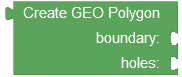
The Polygon data type is represented as a GeoJSON object in the Codeless. This object consists of two properties: boundary and holes:
where:
| Argument | Description |
|---|---|
boundary |
Represents the outer boundary of the polygon. It defines the primary shape or contour that encloses the entire area of the polygon. This boundary forms the outermost shape that encompasses the entire polygon area. Must be a list containing Point objects. To populate the list, you must use the "Create GEO Point" Codeless block for each Point object you want to add. |
holes |
Represents the inner boundaries of the polygon. It specifies additional shapes or contours that are located within the outer boundary of the polygon. These holes create empty regions or cutouts within the main polygon area. Each hole defines a distinct interior area that is excluded from the polygon's total coverage. Must be a list containing the LineString objects populated using the "Create GEO LineString" Codeless block. Each LineString object must also contain a list of Point objects created using the "Create GEO Point" Codeless block. |
Consider the structure of the following data table called geolocation:
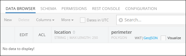
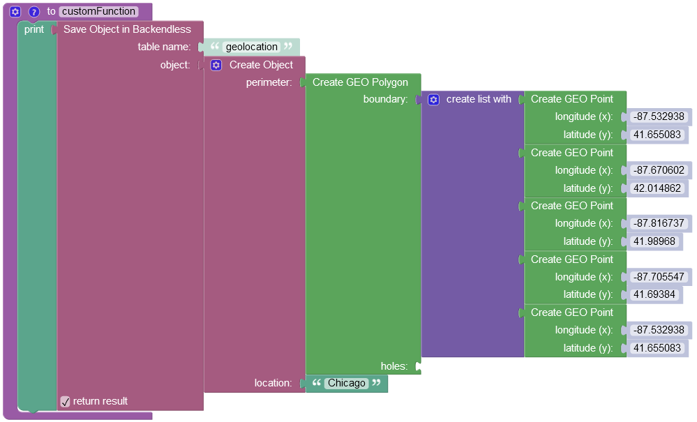
Suppose you need to add a simple polygon(without interior boundaries) to the data table.
Important
The Codeless logic below represents a quadrilateral polygon, which is a geometrical figure with four sides. To create a polygon, the list containing Point objects must have the same longitude and latitude values in both the first and the last objects. The last object is needed to enclose the polygon, completing its shape.
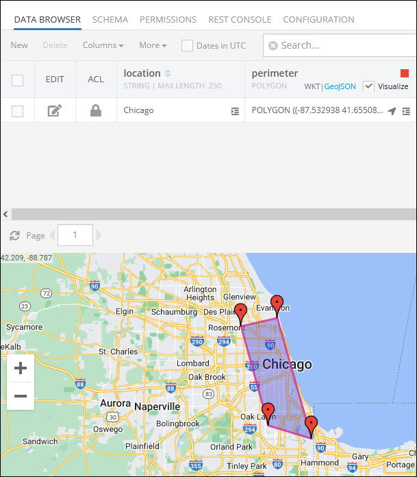
The example below saves a new GeoJSON object(Polygon) to the geolocation data table: As you can see, the Codeless block contains an object with the perimeter property, that represents the column in the data table where the Polygon data objects are stored. The saved object represents the perimeter of the Chicago city.
where:
| Argument | Description |
|---|---|
table name |
Name of the data table where a new record must be saved. |
object |
An object to save in the database. Object properties must match the names of the table columns. The object must not have the objectId property. |
return result |
Optional parameter. When this box is checked, the operation returns the saved object with the objectId property. |
After the Codeless logic runs, the operation adds a new object to the data table:
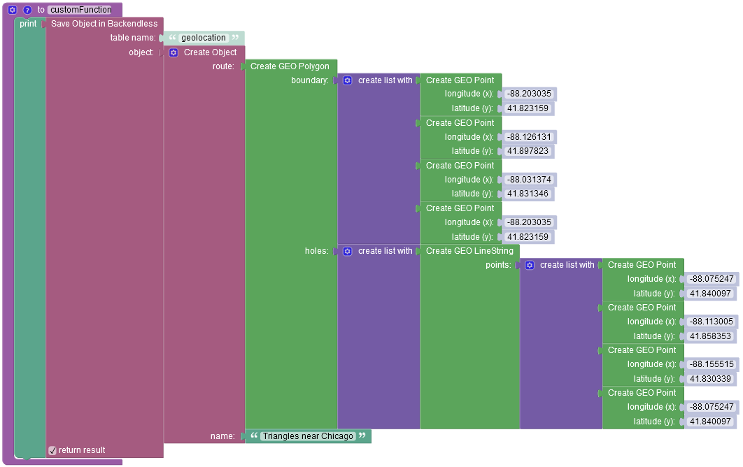
In case you need to add a polygon that contains the interior boundaries, you have to utilize the holes parameter, adding the list containing the LineString objects where each LineString object must also contain a list of Point objects created using the "Create GEO Point" Codeless block.
The coordinates of the interior boundary must be reversed against the exterior boundary. So the first Point of the interior boundary must start closer to the last Point of the exterior boundary: Consider the following screenshot for better explanation:
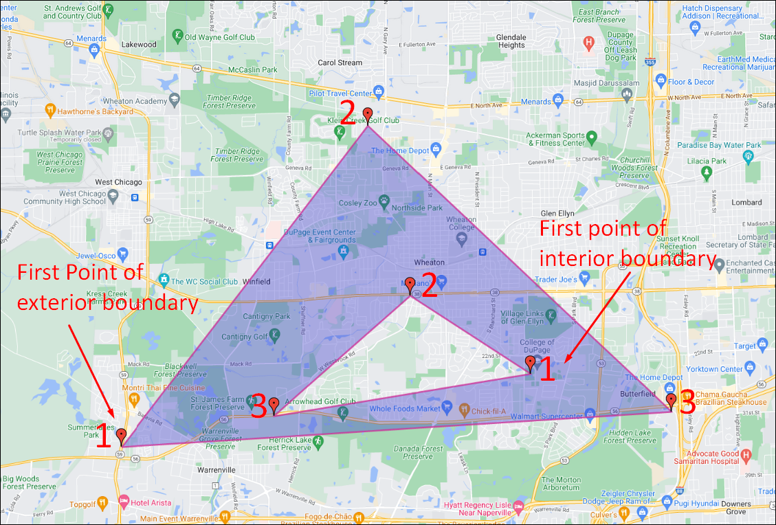
To draw the geometric figure highlighted above, the following Codeless logic is used:
After the Codeless logic runs, the operation adds a new object to the data table: