Spatial Data Create/Update API
Spatial values retrieved from the database are formatted per the GeoJSON specification.
POINT Values
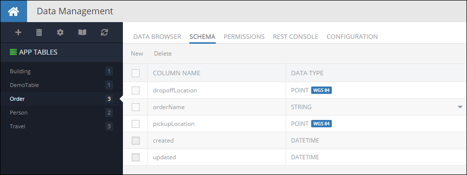
Consider the following table schema in Backendless database. Notice the pickupLocation and the dropoffLocation columns. Both are of type POINT:
The following code demonstrates how to create a new object with POINT properties in the Order table:
Notice the formatting of the dropoffLocation and the pickupLocation properties - they follow the structure of the Point GeoJSON geometry.
**Request method: **
POST
Request header:
Content-Type:application/json
Request body:
{
  "orderName": "Fun times",
  "dropoffLocation": {
    "type": "Point",
    "coordinates": [ 37.6189, 55.752917 ]
  },
  "pickupLocation": {
    "type": "Point",
    "coordinates": [ 37.578639, 55.782309 ]
  }
}
cURL request:
Important
Make sure to replace xxxx in the domain name in the sample request below to the one assigned to your application.
curl \
-H Content-Type:application/json \
-X POST  \
-d "{ \
  "orderName": "Fun times", \
  "dropoffLocation": { \
    "type": "Point", \
    "coordinates": [ 37.6189, 55.752917 ] \
  }, \
  "pickupLocation": { \
    "type": "Point", \
    "coordinates": [ 37.578639, 55.782309 ] \
  } \
}" \
-v https://xxxx.backendless.app/api/data/Order
Codeless Reference
The example below creates a new object containing two GeoJSON (Point) objects and saves it to the database called Order:
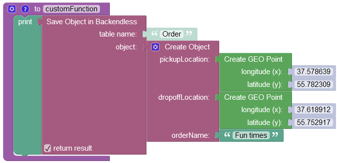
where:
| Argument | Description |
|---|---|
table name |
Name of the data table where a new record must be saved. |
object |
An object to save in the database. Object properties must match the names of the table columns. The object must not have the objectId property. |
return result |
Optional parameter. When this box is checked, the operation returns the saved object with the objectId property. |
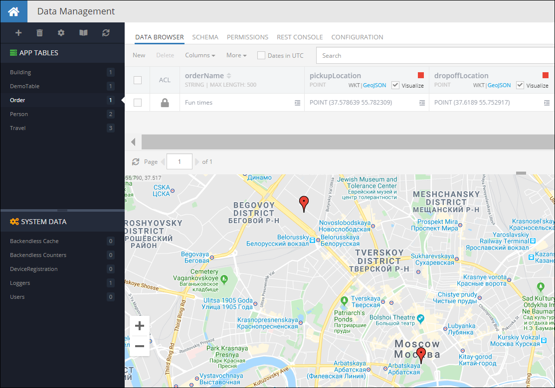
When you run the code(or Codeless logic), you will see the following in the database:
LINESTRING Values
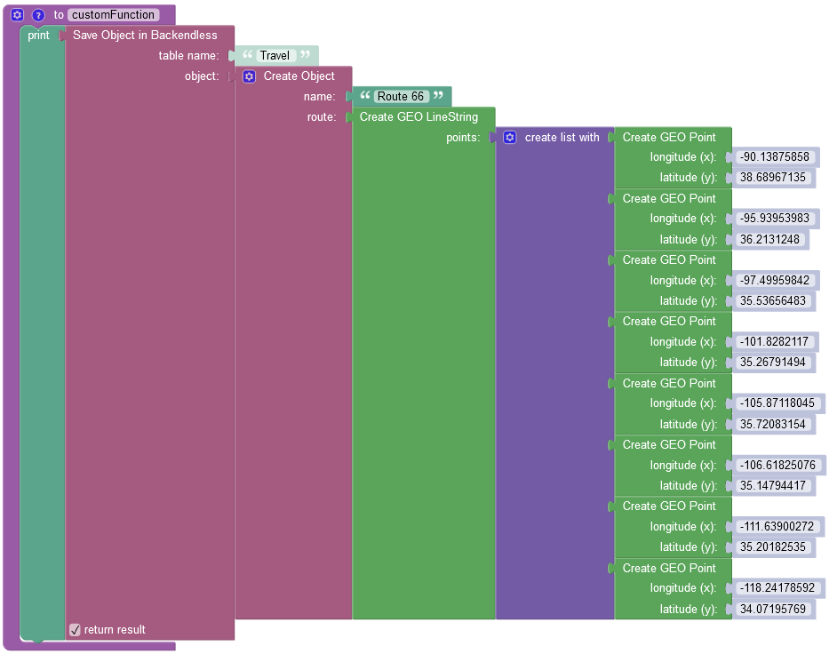
Creating objects with LINESTRING properties works similarly to the example shown above - request must use the GeoJSON format to describe a linestring value. For example, the code below creates an object in the Travel table with a LINESTRING route:
Notice the formatting of the route property - it follows the structure of the LineString GeoJSON geometry.
**Request method: **
POST
Request header:
Content-Type:application/json
Request body:
{
  "name": "Route 66",
  "route": {
    "type": "LineString",
    "coordinates": [
      [ -90.13875858, 38.68967135 ],
      [ -95.93953983, 36.2131248 ],
      [ -97.49959842, 35.53656483 ],
      [ -101.8282117, 35.26791494 ],
      [ -105.87118045, 35.72083154 ],
      [ -106.61825076, 35.14794417 ],
      [ -111.63900272, 35.20182535 ],
      [ -118.24178592, 34.07195769 ]
    ]
  }
}
cURL request:
Important
Make sure to replace xxxx in the domain name in the sample request below to the one assigned to your application.
curl \
-H Content-Type:application/json \
-X POST  \
-d "{ \
  "name": "Route 66", \
  "route": { \
    "type": "LineString", \
    "coordinates": [ \
      [ -90.13875858, 38.68967135 ], \
      [ -95.93953983, 36.2131248 ], \
      [ -97.49959842, 35.53656483 ], \
      [ -101.8282117, 35.26791494 ], \
      [ -105.87118045, 35.72083154 ], \
      [ -106.61825076, 35.14794417 ], \
      [ -111.63900272, 35.20182535 ], \
      [ -118.24178592, 34.07195769 ] \
    ] \
  } \
}" \
-v https://xxxx.backendless.app/api/data/Travel
Codeless Reference
The example below creates a new object containing one GeoJSON (LineString) object and saves it to the database called Travel:
where:
| Argument | Description |
|---|---|
table name |
Name of the data table where a new record must be saved. |
object |
An object to save in the database. Object properties must match the names of the table columns. The object must not have the objectId property. |
return result |
Optional parameter. When this box is checked, the operation returns the saved object with the objectId property. |
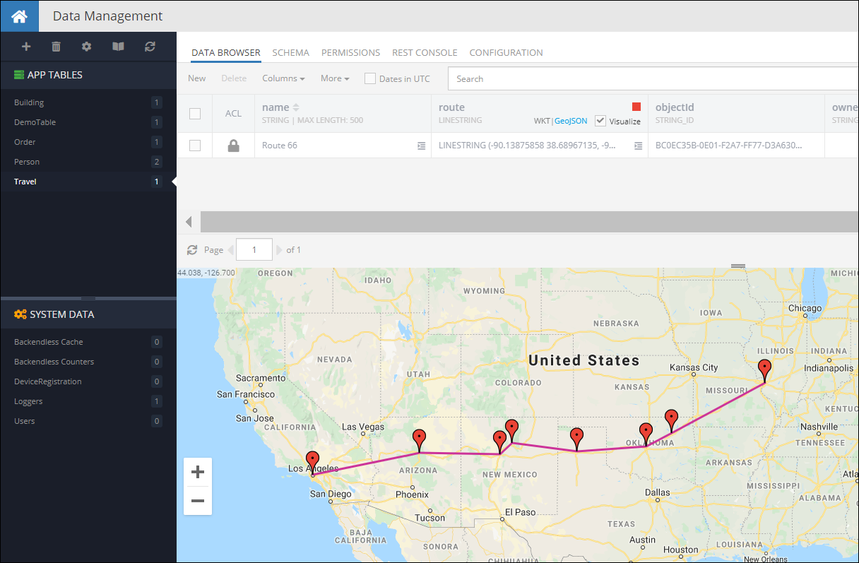
When you run the code(or Codeless Logic), you will see the following object in the database:
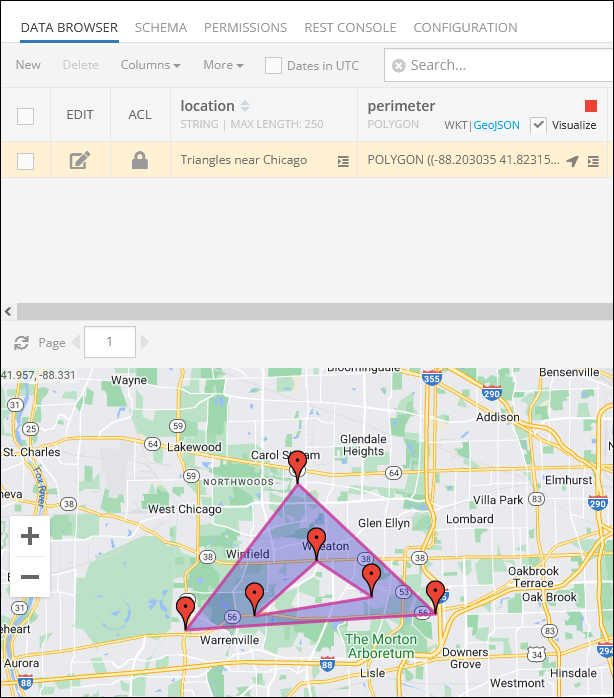
POLYGON Values
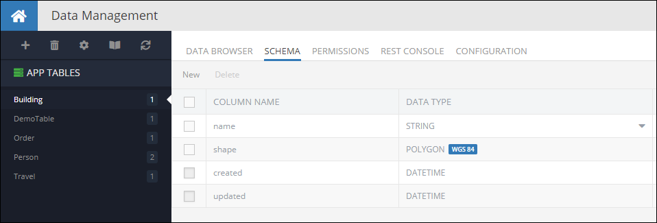
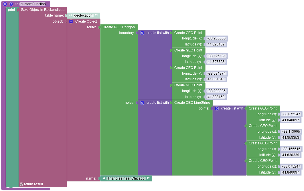
Creating objects with properties of type POLYGON can be done by using the corresponding GeoJSON format. Consider the following example, it is a data table called Building with a schema which includes a column named shape of type POLYGON:
The code below demonstrates how to create a new object with a POLYGON property in the database:
Notice the formatting of the shape property - it follows the structure of the Polygon GeoJSON
**Request method: **
POST
Request header:
Content-Type:application/json
Request body:
{
  "name": "Pentagon",
  "shape": {
    "type": "Polygon",
    "coordinates": [
      [
        [ -77.05786152, 38.87261877 ],
        [ -77.0546978, 38.87296123 ],
        [ -77.05317431, 38.87061405 ],
        [ -77.0555883, 38.86882611 ],
        [ -77.05847435, 38.87002898 ],
        [ -77.05786152, 38.87261877 ]
      ],
      [
        [ -77.05579215, 38.87026286 ],
        [ -77.05491238, 38.87087264 ],
        [ -77.05544882, 38.87170794 ],
        [ -77.05669337, 38.87156594 ],
        [ -77.05684357, 38.87072228 ],
        [ -77.05579215, 38.87026286 ]
      ]
    ]
  }
}
cURL request:
Important
Make sure to replace xxxx in the domain name in the sample request below to the one assigned to your application.
curl \
-H Content-Type:application/json \
-X POST  \
-d "{ \
  "name": "Pentagon", \
  "shape": { \
    "type": "Polygon", \
    "coordinates": [ \
      [ \
        [ -77.05786152, 38.87261877 ], \
        [ -77.0546978, 38.87296123 ], \
        [ -77.05317431, 38.87061405 ], \
        [ -77.0555883, 38.86882611 ], \
        [ -77.05847435, 38.87002898 ], \
        [ -77.05786152, 38.87261877 ] \
      ], \
      [ \
        [ -77.05579215, 38.87026286 ], \
        [ -77.05491238, 38.87087264 ], \
        [ -77.05544882, 38.87170794 ], \
        [ -77.05669337, 38.87156594 ], \
        [ -77.05684357, 38.87072228 ], \
        [ -77.05579215, 38.87026286 ] \
      ] \
    ] \
  } \
}" \
-v https://xxxx.backendless.app/api/data/Building
Codeless Reference
The example below creates a new object containing one GeoJSON (Polygon) object and saves it to the database called geolocation:
where:
| Argument | Description |
|---|---|
table name |
Name of the data table where a new record must be saved. |
object |
An object to save in the database. Object properties must match the names of the table columns. The object must not have the objectId property. |
return result |
Optional parameter. When this box is checked, the operation returns the saved object with the objectId property. |
After running the code(or Codeless Logic), you will see the following object in the database: